Understanding the historical significance and symbols represented in the Babylonian World Map, the first known world map, will likely give us unparalleled insight into the lives of the people. old.
The oldest extant world map is the Babylonian World Map , also known as “Imago Mundi” . It is a clay tablet dating to around 700-500 BC, depicting the world as a round disc with Babylon in the center. It was discovered by Hormuzd Rassam, a British archaeologist, in 1881 in Sippar, a city near Babylon in present-day Iraq, and is now kept at the British Museum in London.
Written in the Akkadian language , the Babylonian World Map is a fascinating artifact that provides insights into the ancient Babylonians’ understanding of the world. It is important to note that the map is not a perfect representation of the world, but it does show that the Babylonians had a basic understanding of geography.
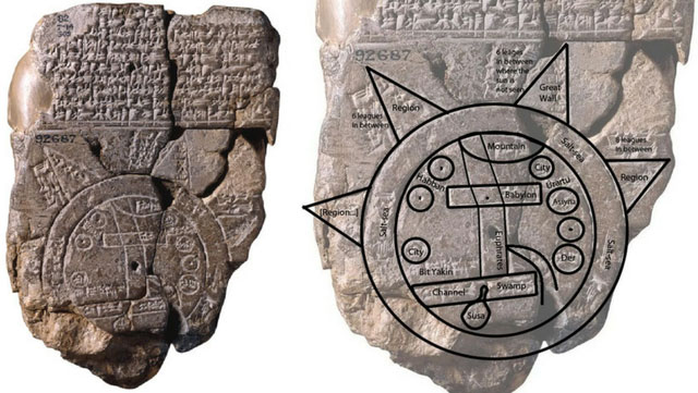 The Imago Mundi, the Babylonian world map, is the earliest earth map discovered. The fifth century BC is when this map was created. This map, discovered in the city of Sippar in southern Iraq, depicts a small part of the world as the ancient Babylonians knew it. This clay tablet was discovered on the east bank of the Euphrates River , north of the ancient city of Babylon.
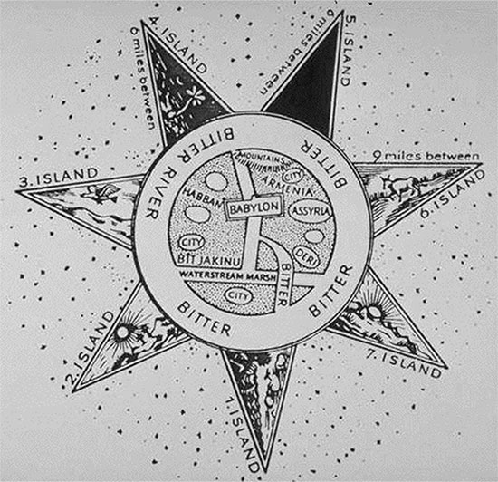
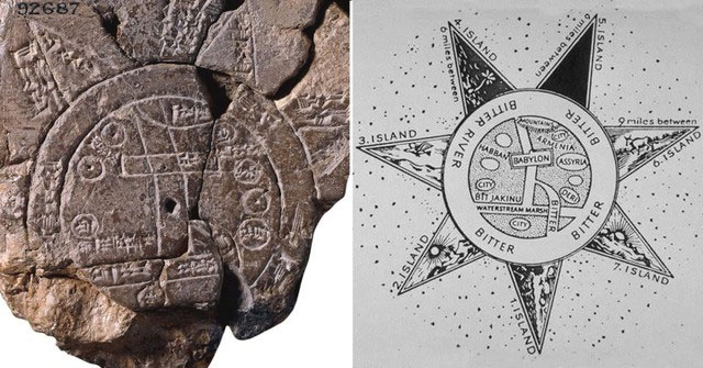
The map is circular and divided into two concentric circles. The inner circle represents the known world, centered on Babylon, shown as a rectangle near the top. This reflects the Babylonian belief that Babylon was the center of the world.
The Euphrates River flows through the center of the map, from north to south through Babylon. Euphrates, a major river in Mesopotamia, played an important role in Babylonian culture and agriculture. The area to the right of the Euphrates is marked as “swamp” and the left end is marked as “outflow”.
Surrounding the city of Babylon on the map are seven cities and seven islands, surrounded by two circles representing bodies of water that may have been near Babylon at the time. Cuneiform text at the top of the label labels each location; The water parameters on the map are labeled “salty sea” and “bitter river”.
 This map shows the Babylonian view of the Earth and sky through the eyes of the Babylonians themselves, placing the city of Babylon at the center of the map. Just as other civilizations did with Athens or Jerusalem, Babylon was placed at the center because it was the center of life for the thousands of people who lived there – this was the only perspective they had when not using the technology. modern technology such as satellites, mapping tools, and reliable long-distance transportation. Their views and ideas about the world around them can be seen through this small map, however incomplete it may be.
Locations on the map are mountains, swamps, a canal, three unnamed cities, the cities of Urartu, Assyria, Der, Elam, Bit Yakin, Habban, Babylon and an unknown location. The parallel lines below the marked city of Babylon are said to represent the southern marshes of present-day Iraq, and another curved line, the Zagros Mountains, can be seen near the city.
Another feature of the map visible in the cuneiform inscription is that it is actually a copy of an even older map of the area, one that has been lost to time and memory . The unique perspective of the map, even a copy of an older creation, shows not only how the Babylonians viewed the world around them but also the mythical kingdom of heaven.
 The islands surrounding Babylon and the known areas surrounding it do not exist in the physical world; they are said to be mythological representations of the connection between Earth and heaven. The back of the map depicts the stars with recognizable constellations that correspond to our modern understanding of the zodiac. The union of heaven and earth, the realities of life around them, and the precise charting of the universe above them led the Babylonians to create the world’s oldest map that still exists today.
The map is not intended to be a factual or geographically accurate representation. Rather, it reflects the worldview and cosmology of the Babylonians , which was influenced by their religious beliefs and cultural traditions. The map shows how the Babylonians considered themselves the center of the world and how they imagined strange and unknown lands beyond their borders. The map also illustrates their conception of the universe as a flat disk surrounded by water, which was a common idea in many ancient cultures.
The Babylonian map of the world is a unique and valuable artifact that gives us a glimpse into ancient thought and helps us understand the development of geography and cartography. It is also a testament to the human curiosity and creativity that has driven us to explore and learn about the world throughout history.