 Geograph
A crowdfunding campaign has been launched in a bid to unearth a long-lost medieval village near Cheltenham.
The village of Sudeley, near Sudeley Castle in Gloucestershire, is thought to have vanished in the 15th century.
Since then, the original location of the village – one of the largest in the region – has never been rediscovered.
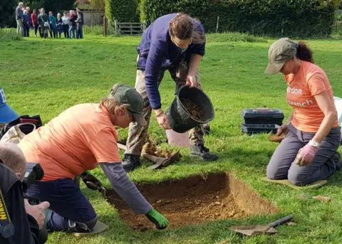
With new evidence on a possible location experts are hoping to raise funds for a two-week dig in later in the year.
Working hypothesis
Recorded in the Domesday Book and occupied for 400 years, the settlement was one of the largest in the region.
Derek Maddock, an archivist at Sudeley Castle, said: “It was quite a prosperous village, we’re talking of something like about 40 families and it’s prosperous until about the 1400s.
“But by about the 1440s it seems to be on the decline and by the1500s it’s almost completely gone.”
He said the reason the village may “possibly” have disappeared was because of Sudeley Castle’s first owner Ralph Boteler.
“He was building for himself rather a large castle and you’re on the second floor of the Great Hall and you’re looking out and seeing these hovels, these villagers – ‘we don’t want those here – let’s get rid of them’,” he said.
“That’s the current working hypothesis,” Mr Maddock explained.
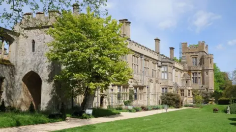
 Sudeley Castle
New evidence from Light Detection and Ranging imagery (LiDAR) has revealed the village’s possible location, including ghostly imprints of a row of medieval housing plots.
The dig will be DigVentures sixth at Sudeley castle, a group enables civic participation in archaeology and heritage projects.
Maiya Pina-Dacier, from DigVentures, said: “One of the most exciting things about archaeology is that you don’t often know what’s going to be there before you start digging.
“But in this case we’ve actually got a fairly good idea.”
She said aerial and LiDAR imagery had revealed the outlines and footprints of some buildings.
“We think they look like they could possibly be the remains of medieval houses and buildings,” she said.
“So at the very least we think that we’ll find some buildings and hopefully some evidence to help date how old those buildings were, when were they in use and when did they finally fall, out of use as well.”
The team hopes evidence collected from the site will contribute to the wider research being done into the history of Winchcombe and the surrounding areas.